Close Menu
Asberth News Network
    Facebook Instagram
    • Home
    • Privacy Policy
    • Terms of use
    • Download App
    Facebook Instagram
    Asberth News Network
    • Home
    • Latest News
    • Breaking News
    • Local News
    • Regional/International News
    • Sports
    • Opinion
    • Back to School
    Asberth News Network
    Home»News»Regional/International News»Saharan Dust from Africa will stretch toward the US, putting the hurricane season on pause
    Regional/International News

    Saharan Dust from Africa will stretch toward the US, putting the hurricane season on pause

    June 17, 20201 Comment2 Mins Read
    Facebook Twitter LinkedIn Email Telegram WhatsApp
    Share
    Facebook Twitter LinkedIn Pinterest Email
    Advertisements

    (CNN) After a quick and active start to hurricane season, it looks like any significant tropical development is unlikely over the next week.

    Advertisements

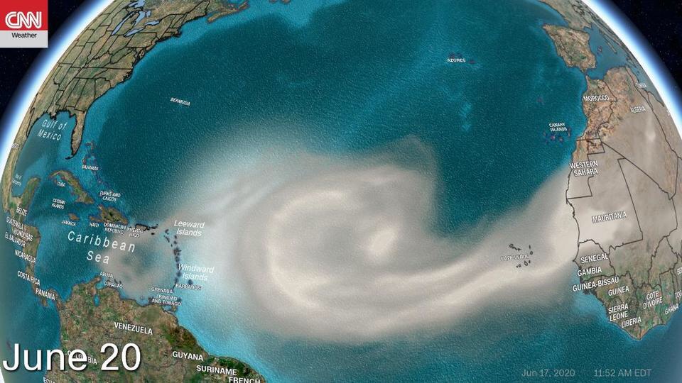
    Its thanks to a significant area of Saharan Dust seen in satellite imagery blowing off the west coast of Africa.


    Forecasting models show the dust moving across the tropics — the main areas of tropical development — and into the Gulf of Mexico by this time next week.


    That means it will travel over 5,000 miles, says CNN meteorologist Haley Brink.


    “Large plumes of Saharan Dust routinely track into the Atlantic Ocean from late spring into early fall,” she says. “Every so often, when the dust plume is large enough and trade winds set up just right, the dust can travel thousands of miles across the Atlantic and into the US.”


    Though the dust is a visible indication there will be little to no tropical development, it isn’t the main reason why a tropical system will not form when it is present.


    “The dust is the visible part of the reduced tropical development potential area,” explains CNN meteorologist Chad Myers. “It is the dry air and additional vertical wind shear along with the dust that are the driving factors in limiting tropical storm development.”


    Vertical wind shear is the change of wind speed and direction with height. For a hurricane to form, it needs little to no wind shear and a very moist atmosphere.


    So, for the next week, don’t expect the Atlantic to see its fourth named storm. Instead, by this time next week, people living and visiting the Caribbean and Gulf Coast beaches will be in for some spectacular sunrises and sunsets.

    Advertisements


    When dust like these travels across the ocean, “the dust particles high up in the atmosphere can scatter sunlight and create some of the most vivid sunsets,” Brink says.

    Advertisements
    Advertisements
    Share. Facebook Twitter Pinterest LinkedIn Tumblr Email

    Related Posts

    US forges ahead with 104% tariffs on China, says willing to talk to other countries

    April 8, 2025

    Trinidad Prime Minister calls   Election – April 28th,2025

    March 18, 2025

    CARPHA Strengthens Regional Laboratory Network with Key Meeting in Trinidad and Tobago

    August 17, 2024

    “Guyana Calls for Transparent Verification in Venezuelan Election, Emphasizes Democratic Integrity”

    July 30, 2024
    View 1 Comment

    1 Comment

    1. PEDRO ANGEL RIVAS TRIAS on June 19, 2020 10:04 AM

      Buen reportaje pero el polvo de sahara ayuda como fertilizante de suelo en Amazonas y otros sectores de América

    Advertisements
    • Home
    • Latest News
    • Breaking News
    • Local News
    • Regional/International News
    • Sports
    • Opinion
    • Back to School
    Our Socials
    • Facebook
    • Instagram
    ANN

    Asbert News Network is the premier destination for local, regional and international news in St. Vincent and the Grenadines. It’s tomorrow’s news today.

    © 2025 Asbert News Network
    • Home
    • Privacy Policy
    • Terms of use
    • Download App

    Type above and press Enter to search. Press Esc to cancel.