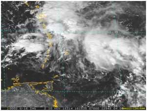
A lower level trough is affecting the region with periods of light rain, moderate to heavy showers and isolated thunderstorm activity. A cyclonic swirl is evident on satellite imagery, centered across the Northern Windward Islands around St. Lucia, Martinique, Dominica and Guadeloupe…(see image at 12:15 pm compliments RAMMB).

Instability and shower activity is likely to spread across parts of mainland St.Vincent. Hence, the FLOOD-WATCH remains in effect for ST VINCENT AND THE GRENADINES until 6:00 pm today and may be upgraded to a Warning if conditions warrant/or extended due to mid-upper level conditions.
Residents and motorists in areas prone to flooding and land-slides; near rivers, streams and low-lying areas should take the necessary precautions.
Another low level trough should near the island chain late Sunday, but moisture is expected to pull away from our area to north-east of the island chain with a possible deepening of the trough. It is expected to move towards the Greater Antilles by mid-week possibly as a cyclone.
Variable wind direction this morning veered to east south-easterly gentle/moderate (10-25km/h) breeze nearing midday, and should vary again by tonight. A veer to south easterly is expected by Sunday afternoon while decreasing to light/calm (less than 10km/h) by Sunday evening. A thin patch of dust could cause slight haze during Tuesday, pushed by increasing wind speeds becoming fresh by mid week.
Slight seas on the west coasts should peak near 1.2m; while on the east coasts slight to moderate seas should peak near 1.8m with east north-easterly swells, wave heights should be increasing by mid-week.
More details on our website….

